South Russia

Taxonomie

Code

Anmerkung(en) zur Eingrenzung

Anmerkung(en) zur Herkunft

Anmerkungen zur Ansicht

Hierarchische Begriffe

South Russia

Equivalente Begriffe

South Russia

Verbundene Begriffe

South Russia

20 Archivische Beschreibung results for South Russia

20 Ergebnisse mit direktem Bezug Engere Begriffe ausschließen

J Mannhardt, Namens Verzeichniss, Danzig

This file consists of the following item:
Manuscript : Namens Verzeichniss der in Deutschland Ost und Westpreussen, Galizien, Polen und Russland befindlichen Mennoniten Gemeinden, sowie ihrer Aeltesten, Lehrer und Vorsteher. - 1 file (Box 241)

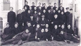
Schoolboys and teachers

School boys and teachers or administrators. Probably Peter Neufeld is in this photograph. The school is probably the same as the one pictured in Hist.Mss.1.350.12.

Unknown

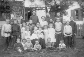
Maria (Fast) Peters and her grandchildren

This portrait is taken at the Bergthal Estate on the occasion of Lydia Peters's marriage to David Boschmann. The mother of the bride, Maria (Fast) Peters, is at the center of the photo (approximate age, 66). The Bergthal Estate was purchased in 1877 by Franz Gerhard Peters, Maria Peters's husband, who had already passed away at the time of Lydia's wedding.

In addition to these notes, Patricia Stabler Peters provided the names of those in the photo based on information from Gerhard I. Peters's memoir, "He leadeth me in right paths" (1994), 58B.

Front row sitting (l-r): Abram Boschmann, John B. Peters, David Schellenberg, David Boschmann, Daniel Boschmann, and Gerhard I. Peters.

Standing (l-r): Bernhard Harder, Franz I. Peters, Bernhard Schellenberg, Mary I. Peters-Harder, Sara Schellenberg, Tina Unger-Martens-Loewen-Enns, Grandmother Peters with Susie Cornies-Ewert and Eliesabeth I. Peters-Warkentin-Klassen, Eliesabeth Boschmann-Rempel, Anna Boschmann-Ponoaroff, and Bernhard Boschmann.

Back row (l-r): Tina Boschmann-Bergmann, Mariechen Boschmann, Franz Boschmann, Justina Dyck-Fast, Franz G. Harder, Abram I. Peters, and Gerhard Boschmann.

At the far back (-r): Franz Peters, Abram Braun, and John I. Peters.

Germany Maps

File consists of the following maps:

1) Karte von Hessen mit den Orten aus denen die Wolgadeutschen ausgewandert sind (1763-69), by K. Stumpp. 67x49 cm. (Map of Hessen with the areas from which the Germans originated who resettled to the Volga region.)
2) Sonderkarte aus der Auswanderungskarte Wuerttemberg und Kreisen: Stuttgart, Ludwigsburg, Heilbronn, Vaihingen, Leonberg, Boeblingen, Esslingen, Waiblingen, Backnang, Oehringen, Nuertingen, Tuebingen u. Reutlingen. Auswanderung in den Jahren 1804-1842 nach Suedrussland, by K. Stumpp. 56x38 cm. (Detail map of the emigration of Wuerttemberg and area. Emigration 1804-1842 to south Russia.)
3) Karte von Wuerttemberg, Baden, Pflaz und Elsass mit den Orten,aus denen die Schwarzmeerdeutschen ausgewandert sind, (1804-1842), by K. Stumpp. 48x45 cm. (Map of Wuerttemberg, Baden, Pflaz and Elsass with the areas from which the Germans originated who emigrated to the Black Sea region.)
4) Orte in Elsass-Lothringen, aus denen Auswanderungen nach Russland stattgefunden haben. (1803-1817), by K. Stumpp, 1969. 66x50 cm. (Areas in Elsass-Lothringen from which emigrants originated who relocated to Russia.)
5) Karte der Orte in Rheinland Pfalz aus denen Auswanderungen nach Suedrussland in den Jahren 1808/1810 stattgefunden haben, by K. Stumpp, 48x66 cm. (Areas of Rhineland from which emigrants originated who relocated to south Russia in 1808/1810.)
6) Orte aus denen im Jahre 1814 Auswanderungen nach Russland, insbesondere nach Bessarabien stattgefunden haben, by K. Stumpp, 1972. 50x88 cm. (Areas from which emigrants who relocated to Russia originated, specifically Bessarabia, in 1814.)

Farm of Mennonite Elder, South Russia

This photo is of a farm belonging to a Mennonite elder in South Russia. On the right side of the photo behind a fence and behind some trees is a house. On the left side of the property is a long low building.There are two arched entrances to the property. A group of people is standing in front of the left entrance. A carriage pulled by two white horses is on an open field in the foreground. Two passengers and a driver are on the carriage. A man is standing behind the carriage.

Unknown

Russia/Ukraine Maps

File consists of the following maps:

1) Barnaul-Slavgorod Settlement on the Kulunda Steppe, handdrawn by G. Fast and Linda Krahn. 22x28 cm.
2) Neu-Samara, Vollost Luyemburg, Kreis Busuluk, handdrawn by J.H Brucks and H. Hooge and Linda Krahn. 21x28 cm.
3) Nikolajewka, Kronstadt, Kolonie Ignatjewo, Bachmuter Kreis; handdrawn. 28x22 cm.
4) Molotschna Mennonite Area, Halbstadt and Gnadenfeld, Taurida Gov't District, 2 maps, drawn by J. Janzen. 20x32 cm.
5) Alexanderkrone, Molotschna, village plan in 1922-1928. D.Peters, handdrawn. 19x33 cm.
6) Burwalde, Chortitza, village plan, 1942; handdrawn. 22x36 cm.
7) Baratow-Schachtjin Siedlung, handdrawn by Jakob Redekopp and Linda Krahn. 20x26 cm.
8) Ohrloff, Molotschna village map, 1918, handdrawn by Gerhard Toews in 1976. 28x43 cm.
9) Kuban villages, Alexanderfeld and Wohldenfurst drawn by J. Wiens and Linda Krahn. 35x30 cm.
10)Die Tereker Ansiedlung, drawn by C. P. Toews and Linda Krahn, 1945. 22x28 cm. (The Terek settlement.)
11) The district of Halbstadt, 1938, supplied by Halbstadt Archives; handdrawn. 2 maps. 36x46 cm.
12) Karte der deutschen Siedlungen in Gebiet Rostow (ehem. Dongebiet).1958; by K. Stumpp. 45x41 cm. (Map of German settlements in the Rostow area (previously Don area).
13) Karte von Siedlungengsgebiete Orenburg/Ufa, Kasachstan, Kirgisien, und Siberien, 1964; by K Stumpp. 31x44 cm. (Map of settlements in the Orenburg/Ufa, Kazakhstan, Kyrgyzstan and Siberia areas.)
14) Karte der deutschen Siedlungen in den Gebieten Omsk, Slawgorod and Zelinograd, 1964; by K.Stumpp. 32x60 cm. (Map of German settlements in the Omsk, Slavgorod and Zelinograd areas.)
15) Karte der deutschen Siedlungen in Raum Alt-Samara, Ufa-Dawlenkanowo, Orenburg, Neu-Samara aund Aktjubinsk, 1964: by K. Stumpp. 48x39 cm. (Map of German settlements in the Old Samara, Ufa-Dawlenkanowo, Orenburg, New Samara and Aktjubinsk areas.)
16) Karte der deutschen Siedlungen im asiatischen Teil der Sowjetunion:Nord-(Siberien) und Mittelasien, 1964: by K. Stumpp. 43x60 cm. (Map of German settlements in the Soviet Union: north Asia (Siberia) and central Asia.)
17) Karte der deutschen Siedlungen in ukrainisch Wolhynien, 1961; by K. Stumpp. 35x56 cm. (Map of German settlements in Volyn, Ukraine.)
18) Karte der deutschen Siedlungen im Nord-und-Suedkaukasus, 1960; by K Stumpp. 44x56 cm. (Map of German settlements in north and south Caucasus.)
19) Karte der deutschen Siedlungen in den Gouv. St. Petersburg (Leningrad) und Nowgorod, 1961; by K. Stumpp. 48x40 cm. (Map of German settlements in the provinces of St. Petersburg (Leningrad) and Novgorod. )
20) Die deutschen Siedlungen auf der Halbinsel Krim, 1959; by K. Stumpp. 35x40 cm. (German settlements on the Crimean Peninsula.)
21) Karte der ehemaligen und heutigen Siedlungsbegiete der Deutschen in der Sowjetunion, 1962; by K. Stumpp. 40x67 cm. (Map of present and previous German settlements in the Soviet Union.)
22) Uebersichtskarte der heutigen Wohngebiete der Deutschen in der Sowjetunion, 1959; by K. Stumpp. 36x56 cm. (Overview of present German areas in the Soviet Union.)
23) Karte der deutschen Siedlungen im Gebiet Stalino, Jekaterinoslaw und Charkow, 1958; by K. Stumpp. 46x37 cm. (Map of German settlements in the Stalino, Ekaterinoslav and Kharkiv areas.)
24) Die deutschen Mennoniten Kolonien in Russland, by K Beil, Muenchen. 31x54 cm. (The German Mennonite colonies in Russia.)
25) Herkunftslaender Wanderwege und Ansiedlungsgebiete (1763-1861) der Wolga-und Schwarzmeerdeutschen in den Mutterkolonien; responsibility unknown. 22x32 cm. (Settlement areas and emigration routes from Germany to the mother colonies in the Volga and Black Sea regions.)
26) Plan der grossen Barnauler Ansiedlung auf der kulundischen Steppe (Westsibierien); responsiblity unknown. 22x28 cm. (Plan of the large Barnaul settlement on the Kulunda steppe in west Siberia.)
27) Neuzeitliche deutsche Siedlungen im Weichfelmendungsgebiet, 1600; responsiblity unknown. 29x35 cm. (Current German settlements in the Weichfelmendungs area.)
28) Erinnerungen aus Ignatjewo im Lichte Geschichtlicher Wandlungen; responsibility unknown. 28x22 cm. (Memories of Ignatiev in the light of historical changes.)
29} Dorf Krasnoja Nr.3, Kreis Arkadak, Gebiet Saratow, RSFSR. Handdrawn by Alfred Rempel. 1993. 22x36 cm. (Village of Krasnoje No.3, Arkadak district, Saratov territory, Russian Soviet Federative Socialist Republic.)

MCC Small Collections

  • US MCC US IX-04
  • Serie
  • 1937-present

Various subjects and time periods

Mennonite Central Committee (Akron, Pennsylvania)

Die Mennoniten Gemeinden in Russland

This file consists of the following items:
1) Die Mennoniten-Gemeinden in Russland waerend der Kriegs and Revolutionsjahre 1914 bis 1920.
It is translated and expanded from Dutch and published by Kommissions-Verlag der Mennon. Fleuchtlingsfeursorge E.B. in Heilbron 115 pages.
2) Protokoll der erweiterten Siztung des Missionskomomitees der Mennoninten-Brueder-Gemeinden in Russland am 28 Juni 1918.
1 page,
3) Protokoll des Allgemeinen Mennonitischen Kongresses in Ohrloff, Taurien vom 14-18 August 1917. - (3 files) Box 241
4) Protokoll des Allgemeinen Mennonitischen Bundeskonferenz im Bethaus zu Lichtenau, 1918. 26 pages..
5) Protokoll der Jahressitung der Vereinigten Christlichen Taufgesinnten Mennoniiten Bruedergemeinde in Russland, Mai 1912. Ruekenau, 8 pages.

  • Box 241

Mennonitische Fluechtlingsgemeinde

Ergebnisse: 1 bis 15 von 20