
- CA MHC 715-22.0
- Item
- 1912
Map of the agricultural field of the village of Chortitza as they were farmed in 1912. Original map was created by William Pauls. This copy drawn by N. J. Kroeker.
Stoesz, Dennis, 1954-
4 results directly related Exclude narrower terms
Map of the agricultural field of the village of Chortitza as they were farmed in 1912. Original map was created by William Pauls. This copy drawn by N. J. Kroeker.
Stoesz, Dennis, 1954-

Northern half of Rosenthal village map
This is the other half of the map, showing the northern half of Rosenthal. The border between the adjacent villages of Rosenthal and Chortitza is visible at the top right. Both villages were within the larger Chortitza Mennonite Colony on the Dnieper River in Ukraine.
Kroeger, Peter P., 1918-2002
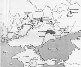
Route Jake Funk took to find Anna Janzen's family
This is a copy of a map showing the route taken by Jacob Funk during his month-long search for Anna’s family in 1921. Map of Mennonite colonies in South Russia by William Schroeder (scale: 1 inch = 50 miles).
Unknown
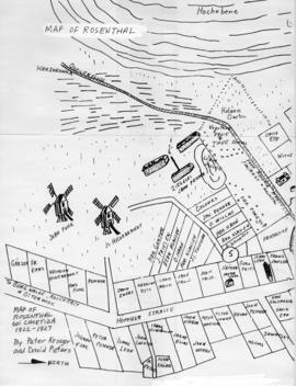
Southern half of the Rosenthal village map
Kroeger, Peter P., 1918-2002