At 1. is the Waterloo County poor house (jail); 2. the County poor house hospital; and 3. the County poor house graveyard without any markers. Used in Hannes Schneider, p. 124A.
A car driving in front of what is assumed to be Reverend W.F. Bindeman's home on King St. The Reverend later moved to Young St. where he died. Used in Hannes Schneider, p. 120H.
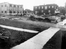
Alex. Millar's home, Queen St. North, in the 1890's; later St. Peter's church parsonage. The building was demolished in 1938. Used in Hannes Schneider, p. 323.
The Old Homestead Pick Wick [Miniature] Golf Course on Queen St. South with an automobile parked in front. Used in Hannes Schneider, p. 126. Near duplicate photo included.
Schneider's Creek adjoining the homestead covered in 1930. Used in Hannes Schneider, p. 150A. A duplicate photo and a near duplicate photo are included.
The fence is the boundary between the land of Joseph M. Snyder (left) and the land of Edith Quickfall. Legal letter confirming this boundary is on the back of the photo. Used in Hannes Schneider, p. 110A. Duplicate included.
A sketching of the "Red" school house by J.G. Stroh. The building was demolished in 1857. Used in Hannes Schneider, p. 120G. Write-up included with photo.
A sketching of the buildings on the north side of King Street between Queen St. and Frederick St. Used in Hannes Schneider, p. 120G. Related photograph in file 1994-1.46.
West Pipe company, owned land south of the David B. Schneider homestead which was torn down to make way for the Conestoga Parkway.This road continued to Nine Pines School house and on to Mannheim. Found in Hist. Mss. 168.2.1.


![The Old Homestead Pick Wick [Miniature] Golf](/uploads/r/mennonite-archives-of-ontario/4/e/8/4e84f5d8125307786466b0b7813d1b75d98de75d0593bbfe89f467e710b16b2e/21_142.jpg)
![A closer view of the Pick Wick [Miniature] Golf](/uploads/r/mennonite-archives-of-ontario/5/2/2/5228ab02c5a0a3b39d848c8c7b2fe17143a43e42ead8c3d6d172fa5855135cc4/22_142.jpg)