
- CA MHC PP-4-044-638.0
- Item
Part of Gerhard Lohrenz fonds
This is a photo of the windmill locally known as the "Buschmuehle". [HR 6]
39 results directly related Exclude narrower terms
Part of Gerhard Lohrenz fonds
This is a photo of the windmill locally known as the "Buschmuehle". [HR 6]

Part of Gerhard Lohrenz fonds
This is a photo of an historical windmill. [HR 35]

Part of Gerhard Lohrenz fonds
This is a photo of a windmill that was the landmark in the homeland of our forebears. They carried the water from the low places into the canals or rivers. [HR 8]
Where Once They Toiled (Poland) by Edward Brandt
Part of Evangelical Mennonite Conference (Kleine Gemeinde) Fonds
"Where Once They Toiled (Poland)" by Edward Reimer Brandt. 1992 A book describing a group tour (and related history) taken in 1991 to Poland under the guidance of Dr. Peter J. Klassen and Dr. Paul Toews. Includes photos.
Brandt, Edward R., 1931-2013

Part of Gerhard Lohrenz fonds
This is a photo of the watchhouse on the dyke along the Vistula River. [HR 6]

Three men seated, with their wives standing beside them - unidentified.
Unknown

Part of Wojiech Marchlewski Polish Mennonite Sites Photo Collection
This photo is of a painting showing a man in stocks, which were a legal form of punishment frequently used by Polish land owners, with people standing around observing.

The home of Charlotte Wiebe's brother Bernhard & family
This photo is of a building on the property of Charlotte Wiebe's brother, Bernhard. A tractor is on one side of the photo and two horses are standing beside it. A young man is standing behind the horses as they pull out a farm implement from the barn. The barn has a metal roof.

This photo is of the stove in the living room of Charlotte Wiebe's house. The stove is made of white stone tiles with a beautiful stone design in the centre. The edges of the stove are of a slightly darker stone with a design engraved in them.
The Schroeder family. Standing: six adults, Seated: five adults with two children.
Part of Gerhard Lohrenz fonds
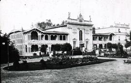
The inscription on this photograph read "Sanatorium Broesen Danzig"
Part of John B Toews fonds
This file consists of the following items:
1) Memoir by Peter D. Froese in German: Erinnerungen aus meiner Deniken-Wrangel Armee. 31 pages
2) Transcribed and translated by Katharine Hooge: " Recollections of my time of service in the Denikin-Wrangel Army and my stay in Turkey". 24 pages. Box 258
Froese, Peter David 1896-1959
Collection consists of the following maps:
1) 1677 Danzig 1944 - 46x45 cm
2) 1678 Weichselmuende 1943 - 46x45 cm
3) 1679 Nickelswalde 1940 - 46x45
4) 1777 Praust 1936 - 46x45 cm
5) 1778 Trutenau 1943 - 46x45 cm
6) 1779 Schoenberg 1940 - 46x45 cm
7) 1780 Tiegenhof 1940 - 46x45 cm
8) 1781 Jungfer 1935 - 46x45cm
9) 1782 Cadinen 1935 - 45x46 cm
10) 1879 Gr. Lichtenau 1940 45x46 cm
11) 1880 Neuteich 1928 45x46
12) 1881 Zeyer 1937 - 45x46 cm
13) 1882 Elbing 1911 - 45x46 cm
14) 1979 Gnojau 1940 - 45x46 cm
15) 1980 Marienburg 1905 45x46 cm
16) 1981 Posilge 1904 45x46 cm
17) 1892 Thiergart 1911 45x46 cm
18) 2079 Wernersdorf 1939 45x46 cm
19 2080 Stuhm 1906 45x46 cm
20) 2279 Marienwerder 1906 45x46 cm
National Collection of Prussia
Prussia/Polish/Netherlands Maps
Part of Miscellaneous Maps fonds
Series consists of the following maps:
1) Neue Verkerhrskarte der Provinz Westpreussen, 40x44 cm. Map of West Prussia.
2 The Danzig Area, 1914, 12x18 cm. (indicating Mennonite settlements)
3) Karte des Freistaates Danzig, 50x69 cm. (shows borders of Germany and Poland as of 1920.
4) Das deutsche Siedlungsgebiet in Polnisch-Wolhynien, 39x57 cm.German colonies in Poland.
5) Nederland (Netherlands) Tourist map, 105x80 cm, with index, legend, milage chart, trip tips in Dutch language
Miscellaneous Maps

This is a photo of (left to right): Remigivsz Slvsarski, Lois Garber and Mr. Slvsarski. They are examining the first tractor owned by the family.
Garber, Jay