
- CA MHC 730-11
- Item
- [1913?]
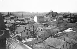
This is a photo of the Town of Steinbach looking northwest. The photo was taken from the mill roof. The white two-storey building in the distance is a school. There are some large gardens .
Unknown
103 results directly related Exclude narrower terms
This is a photo of the Town of Steinbach looking northwest. The photo was taken from the mill roof. The white two-storey building in the distance is a school. There are some large gardens .
Unknown

This is a photo of the Town of Steinbach as seen from the mill roof looking northwest. In the foreground there two rows of piled up logs.
Unknown

This is a photo of the Town of Steinbach as seen from the mill roof looking northwest. The white building in the upper right is identified as the school.
Unknown

This is a photo of the Town of Steinbach as seen from the mill roof looking northwest.
Unknown

Photo taken from roof of grain elevator facing west along 6 Street at corner of Railway Avenue
Unknown

Photo taken from grain elevator facing west along 6 Street at corner of Railway Avenue.
Unknown

Steinmann Mennonite Church (Baden, Ont.) Aerial
Steinmann Mennonite Church (Baden, Ont.) Aerial view
St. Jacobs, Ontario, taken from United Church steeple
Part of David L. Hunsberger collection
Copy of an undated photograph of St. Jacobs, Ontario, taken from United Church steeple. Copied July 1987. Hunsberger photo 72-34
Hunsberger, David L.

St. Jacobs aerial survey. St. Jacobs, Ontario.
Part of David L. Hunsberger collection
St. Jacobs aerial survey. St. Jacobs, Ontario. 1979. Hunsberger photo 72-28
Hunsberger, David L.

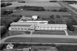
Schools - CMBC - Aerial View of College Grounds
This is a photo of an aerial view of CMBC (Canadian Mennonite Bible College) taken in winter, looking south at Shaftesbury Blvd and Grant Ave. Dormitory, class rooms, skating rink are visible. The residence (house) is under construction. This photo was part of a large display board. The photos were removed from this board July 23, 2007. It was previously known as outsized print #9 acc, #52.
Unknown
Rosthern Junior College - Campus
This is a photo of the RJC campus. An aerial view.
Unknown

Rosthern Junior College - Campus
This is a photo of an aerial view of the RJC campus.
Unknown

Part of Photo Collection from RJC files
Aerial view of Rosthern looking north-east.
Unknown

Plowed fields in the vicinity of the museum
Negatives also (2). Two views of plowed fields in the vicinity of the museum. One field has large semi circles in the middle of it, making it picturesque. In this photo the museum is visible above the field.
Unknown
Photos taken from an airplane near Gander, Newfoundland
Seven photos taken from an airplane showing a peninsula & coastal settlement in Nfld. Taken while enroute to Gander? The photos were together with ones showing the high school at Gander.
Unknown