
A bridge crossing a river in Northern Ontario.
- CA MAO Hist.Mss. 10.28-DH-1798
- Item
- 1950
Part of David L. Hunsberger collection
A bridge crossing a river in Northern Ontario. Photo taken in the 1950s. Hunsberger photo
Hunsberger, David L.
88 results directly related Exclude narrower terms
A bridge crossing a river in Northern Ontario.
Part of David L. Hunsberger collection
A bridge crossing a river in Northern Ontario. Photo taken in the 1950s. Hunsberger photo
Hunsberger, David L.


A group outing at Elora in front of a photographer's backdrop
A group outing at Elora with a bridge in the background. Back row, left: David Betzner; front row, second from left: Catherine Brubacher Betzner.
Unknown
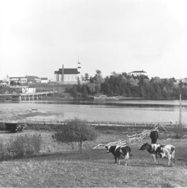
A photograph of a Kouchibouguac church (in the background) taken from across the Kouchibouguac River (with grazing cattle in the foreground). Not found in CM.
Unknown

Part of Jacob D. Epp family fonds
Unknown

A Paraguayan landscape of a bridge and a creek.
A Paraguayan landscape of a bridge and a creek. Not found in CM.
Epp, Bruno, 1927-2012

A plaque marking the historical significance of
A plaque marking the historical significance of the West Montrose Covered Bridge--the last such bridge in Ontario. Not found in CM.
Buhr, Martin

A span of the Fraser River bridge dropped into the river, 1955
Used in the CM 3-29-2. A span of the Fraser River bridge dropped into the river on a Sunday morning. The Frank Krahns were in the second last car to drive over it, on their way to church.
Unknown

A span of the Fraser River bridge dropped into the river, 1955
The collapsed bridge from a different angle. See 14.2528.
Unknown

A view of a main street in New Westminster,
A view of a main street in New Westminster, British Columbia with two bridges in the background crossing the Fraser River. Not found in CM.
Unknown

A view of Montreal looking West. In the
A view of Montreal looking West. In the background is the harbor (left) and the Jacques Cartier bridge (middle) spanning the St. Lawrence to St. Helen's Island. Donated by: Montreal Municipal Tourist Bureau. Not found in CM.
Unknown

Altona Council - tour to Lake of Woods and Lake Superior
Part of Heinrich H. Hamm fonds
While touring north western Ontario, the Altona Council stopped to examine a bridge crossing Berry Creek in the Lake of the Woods area. Location of this bridge is possibly on Highway 71 a few miles north of Sioux Narrows, Ontario. A trunk highway connecting Kenora and Fort Francis was established in the 1930s. For many years the world's longest single span timber bridge (completed in 1936) stood on Highway 71 at Sioux Narrows. The Council certainly must have had some interest in this highway and the bridges along its route, and how it might relate to their jurisdiction in southern Manitoba.

An aerial view of Montreal shows how the
An aerial view of Montreal shows how the skyscrapers are changing the face of the city. In the background are the harbor and the Jacques Cartier Bridge. Not found in CM. Similar to file photograph in 1994-14.391.
Unknown

This photo is of the Weichsel [Vistula] River with the new bridge, built in 1973, in the background. The river here has a strong current and whirlpools. On the left side of the photo shrubbery can be seen. An electrical transmission tower can also be seen in the background. This tower transmits power to Konigsberg Elbing.

Arab refugees crossing the Jordan River? via the
Arab refugees crossing the Jordan River? via the Allenby Bridge? Not found in CM.
Unknown